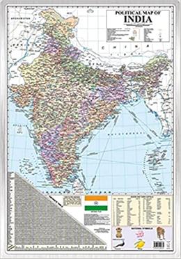
Political Map Of India

Political Map Of India (Hardcover)

Latest Map Of India With The Two New Union Territories Of Jammu

TK. 358

বর্তমানে প্রকাশনীতে এই বইটির মুদ্রিত কপি নেই। বইটি প্রকাশনীতে এভেইলেবল হলে এসএমএস/ইমেইলের মাধ্যমে নোটিফিকেশন পেতে রিকুয়েস্ট ফর রিপ্রিন্ট এ ক্লিক করুন।

book-icon

Cash On Delivery

mponey-icon

7 Days Happy Return

Similar Category eBooks

Customers Also Bought

Product Specification & Summary

This is a syllabus friendly political map of India meant for students. The student can study about the geographical locations of states and Union territories, their capitals and other important cities. It also depicts major shipping routes, sea ports, air ports and National highways. The map depicts the accurate flow of Rivers and lakes, National parks and sanctuaries, glaciers, Coral reefs and major lakes. These additional valuable information will help the student learn more about India's Geography. The map is sturdy and can withstand lot of wear and tear without getting crumpled. The map is easy to hang on a wall with a nail. The dimensions of the map are 30 inches X 20 inches and have been approved by survey of India. This map is also useful for UPSC, SSC, Banking, Railways and other competitive exam preparations.
Title Political Map Of India
Author
Publisher
ISBN 9789354400735
Edition First edition :2021
Number of Pages 1
Country India
Language English

Sponsored Products Related To This Item

Reviews and Ratings

sort icon

Product Q/A

Have a question regarding the product? Ask Us

Show more Question(s)
loading

Similar Category Best Selling Books

prize book-reading point
Superstore
Up To 65% Off
Recently Viewed
cash

Cash on delivery

Pay cash at your doorstep

service

Delivery

All over Bangladesh

return

Happy return

7 days return facility

0 Item(s)

Subtotal:

Customers Also Bought

Are you sure to remove this from bookshelf?

Write a Review

Political Map Of India

Wonder House Books

৳ 358 ৳358.0

Please rate this product